Corfe Castle. 3D Survey and Photogrammetry model
A Norman masterpiece building
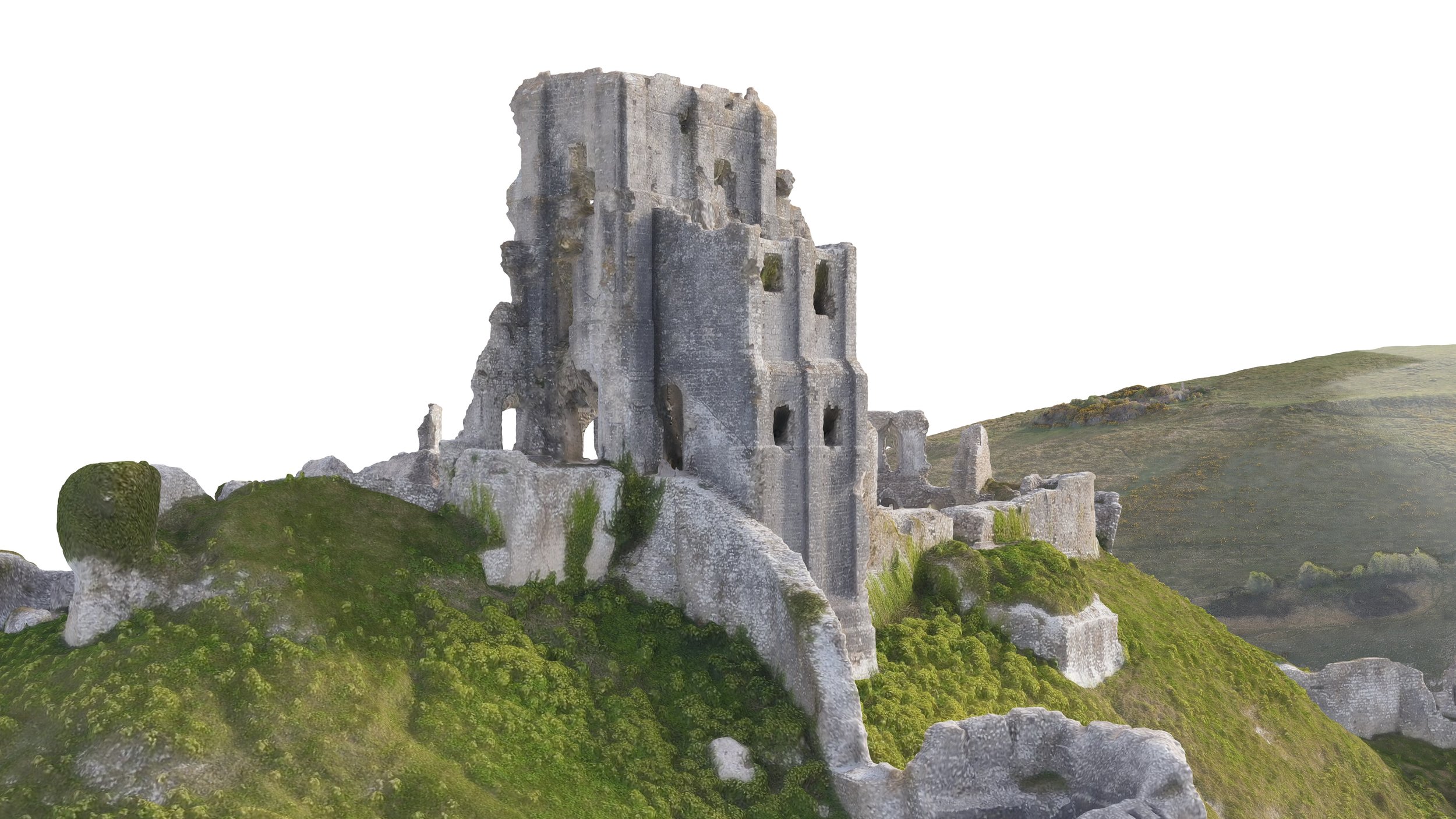
The remains of Corfe Castle stand above the village of the same name on the Purbeck peninsula in the English county of Dorset. Built by William the Conqueror, the fortification dates to the 11th century and commanded a gap in the Purbeck Hills on the route between Wareham and Swanage. William was the Duke of Normandy, and this castle is showing the power at the time of the Normans who invaded Britain.

Visualization of the 3D Model
Drone Mapping and photogrammetry capture process
I planned to scan it while visiting Dorset over Easter to develop a 3D model for my private collection of historical places. There was no purpose in using the model for any commercial survey tasks but found these ruins quite evocative and beautiful so decided to go ahead and scan it. For the task, I used a professional DJI “Enterprise Advanced” drone and flew it in preprogrammed mission for Oblique image capture. The task required some time and several batteries, but the wait was worth the results obtained.


Image post-processing and 3D photogrammetry assembly
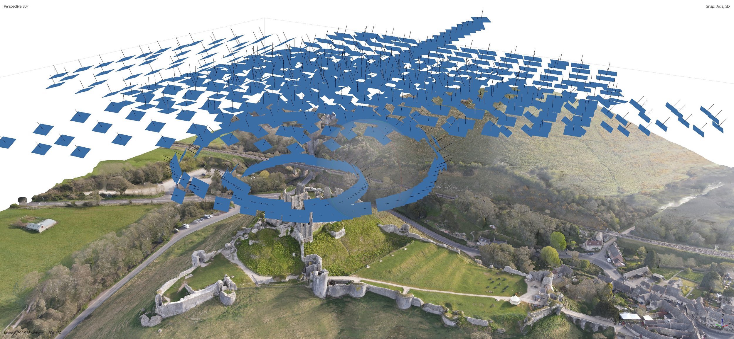
For this exercise, I took around 1000 geolocated pictures. I had to get a few hundred closer to the main body of the building to allow a higher level of detail. With photogrammetry software, it’s possible to process all the images to obtain the 3D model with high accuracy, and a great level of detail. The more pictures you obtain, the more detail you can get, but this would require longer flight times and more batteries. The images below show the positions of the shots taken and its capture angle.

Mesh editing for interactive online visualization
Once I got the model ready in 3D I had to clean it up and post-process the geometry with other special mesh cleaning algorithms. This allows it to reduce its weight and polish its level of detail so it can be visualized interactively, as the model below these lines. The “Sketchfab” interactive model requires lower mesh and texture resolution but still, the level of detail is preserved in the original 3D. The images with higher resolution, which you can see in this post, belong to that original high-resolution model.
Pay attention to the areas identified in this castle as they talk about its different expansions. The first phase was one of the earliest castles in England to be built at least partly using stone when the majority were built with earth and timber. Corfe Castle underwent major structural changes in the 12th and 13th centuries.
The Corfe Castle Footprint
With the model in 3D, we can see today the location of the remains and understand better its footprint. Currently, the footpaths marked in lighter colour show the passages people are using to visit its remains. Some of them like the ones with staircases, mark the original footpaths used by its inhabitants to access the different places of the castle premises and chambers. This castle is managed currently by the “National Trust”, a UK conservation charity, which takes care of its maintenance and visitors control.


Truntable and 3D Virtual Assesemnt
The animations below shows the level of resolution achieved with this drone flight, and the workflow I applied to get this 3D model.
Studies of structure degradation and terrain displacements.
I always work on achieving hight resolution textures to be mapped on meshes with lower polygon count. This ensures lighter models for visualization purposes that can be used for different types of surveys, like topographic, heritage or archaeological ones. If these models are produced periodically they can be used to create comparative studies, to trace the evolution of the remains degradation, potential volume displacements, and evaluation of alterations in the main structures.