The Island of “Isla Plana” is located nearby the fishing village of La Azohía, belonging to the municipality municipal district of Cartagena ( Region of Murcia, Spain ), located at the Gulf of Mazarrón. It surroundings are considered Protected Naural Area. The interactive 3D model below will show you the geography of the island. Explore its interest points by clicking on the numbers
Explore the Underwater Posidonia Meadow
The underwater landscape It is surrounded by an important Posidonia meadow which is the habitat for a wide variety of fish and other sea creatures. Below you can see images of our underwater expedition. We took 360 photos to observe the current state of the water and its life as you can see in the virtual images below. Drag and slide to move the camera and explore the seabed. Common species that can be found in this location are grouper, haddock, shi drum, seabream, slipper lobster, and marine phanerogams (“Sea Grass” and Posidonia) among other species. Isla Plana is a small Island but due to the species that inhabit it on its surface and beneath it, the island it’s considered an area of special natural interest and it belongs to the Natura 2000 conservation program. This is a network of core breeding and resting sites for rare and threatened species and some rare natural habitat types which are protected in their own right. It stretches across all 27 EU countries, both on land and at sea. The aim of the network is to ensure the long-term survival of Europe's most valuable and threatened species and habitats, listed under both the Birds Directive and the Habitats Directive.
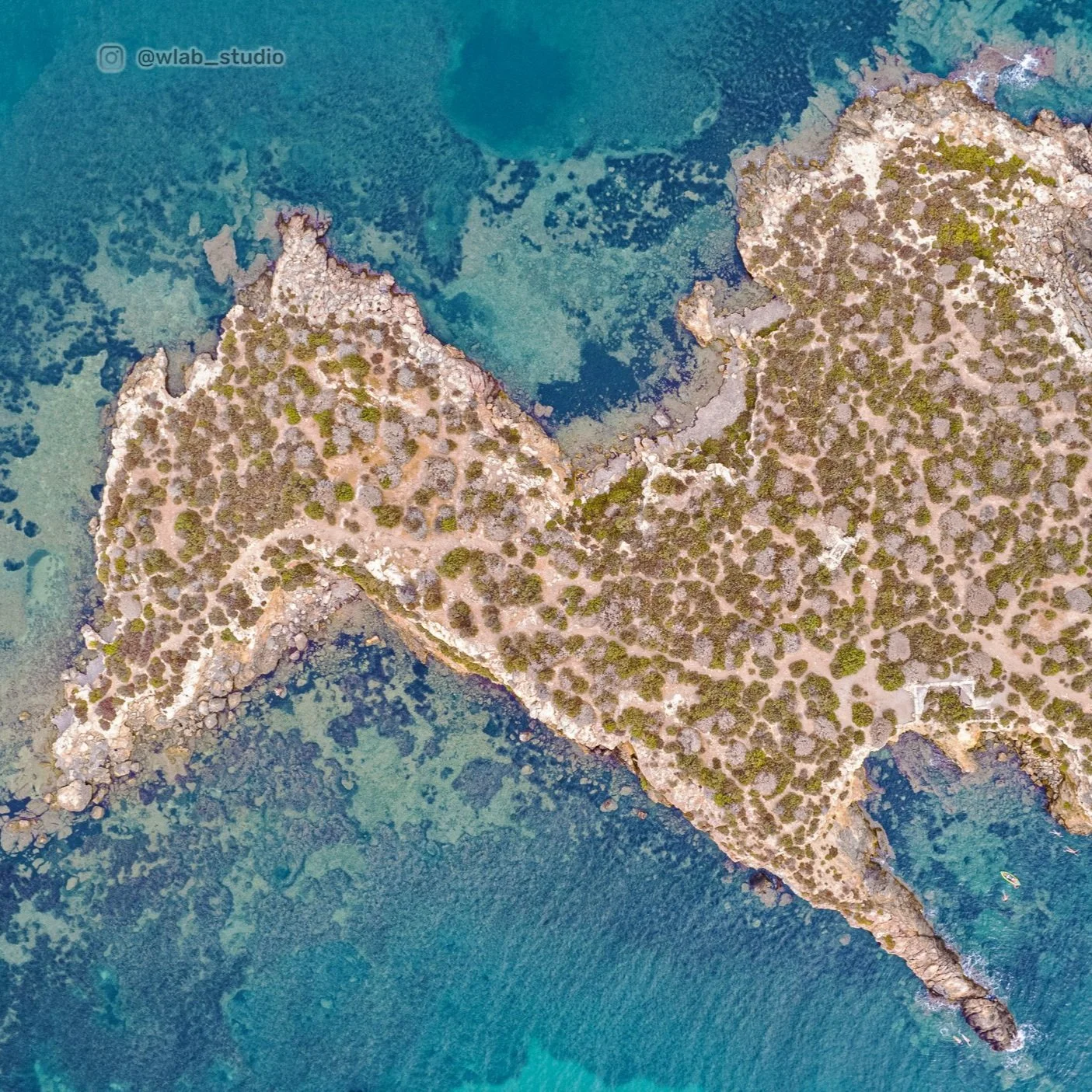
Isla Plana Top view
The image below shows the shape of the island from top view. The crystal clear water allows us to even see the algae and sea plants location and density. Unfortunaltey due to boats anchoring many places surrounding the area, where cleared out from posidonia meadow. At the moment the boats are not allowed to anchor anymore, so the are forced to secured themseleves to different mooring points.

Geology and the Mineral Waters
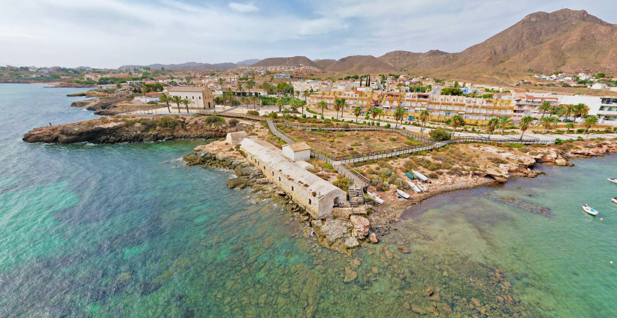
The rocks composing the island are mainly Triassic Calcites. Due to the rock porosity and composition of the area, mineral water was carried from the mountains all the way down to this location. Medicinal spring waters emanated at this point, which gave this location special importance. For almost a century ( between 1876 and 1976) the waters could be enjoyed in a public bathhouse which it´s remains are well preserved on the coast of Isla Plana. The aerial images we took show the public bathhouse on the edge of the coast of Isla Plana town.

Isla Plana Bathhouse plans:
Exterior Main entrance to the vaults
Windows facing the sea
Entrance to the cold general baths with gender separation
Seashore Entrance to the cold general bathroom without gender distinction
General cold baths, separated by gender
General cold baths unisex
Private bathrooms with bathtubs supplied with hot water
Water inlet from a well located 100 meters away
Water tank, below the boilers
Water lifting mechanism
Excess water outlet
Ticket Office
Dining room with marble tables
Below you can see the map of Isla Plana and its Location
Photogrammetry, 3D model and photography its all original from WDS-LAB studio
Information sources and bath house plans:
http://www.cuevashipogenicasdemurcia.es/BIBLI/015-aguas%20mineromedicinales%20isla%20plana.pdf
https://www.regmurcia.com/servlet/s.Sl?sit=a,55,c,365,m,1753&r=ReP-22011-DETALLE_REPORTAJES